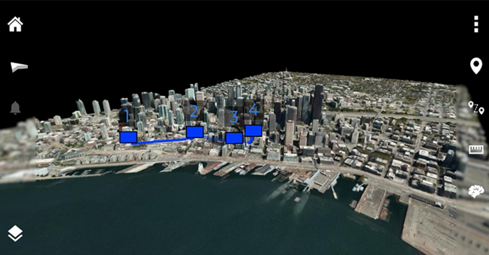
Reveal Technology and Maxar are pleased to announce a partnership to incorporate Maxar’s high-resolution satellite imagery and 3D data directly into Farsight. To improve users’ ability to visualize large-scale geospatial environments, Reveal is integrating Maxar’s high-resolution basemaps and 3D data into Farsight, significantly enhancing operational decision-making at the tactical edge. Maxar data enables accurate 3D terrain visualisation, mission rehearsal, and dynamic coordinate extraction in environments where organic ISR is limited or unavailable.
Farsight is a scalable, mobile-first software platform for use in decentralized, comms-limited environments, providing rapid intelligence at the tactical edge. Farsight processes ISR feeds into a set of 2D and 3D models in mere moments. Users have access to robust in-app measurement, analytics, and autonomy tools, and can import/export map tiles and data layers to platforms like ATAK. Through this partnership, the warfighter now has the option to include trusted Maxar data as a basemap layer to increase the accuracy of operational planning across multiple mission sets.
Reveal’s VP of Security & Defense, Dave Caudle, remarked, “Warfighters consistently praise the analytics and intuitive design of the Farsight product. Now with Maxar, they can experience the same ease of use and mission-focused functionality, enhanced with Maxar’s high-resolution imagery, delivered directly to the point of need: the end-user device in the hands of the tactical warfighter.” This integration represents a major step forward in both Reveal and Maxar’s mission to provide cutting-edge situational awareness tools to defense and security professionals operating at the tactical edge.