Teledyne Imaging, through the geospatial technology portfolio, is advancing integrated mapping and surveying solutions designed to support land, coastal, marine and subsea geospatial operations. The company combines advanced lidar sensing systems, sonar technologies, imaging platforms and data processing software to deliver end-to-end geospatial workflows for mapping, inspection, environmental monitoring, hydrography and infrastructure applications.
A major component of the company’s geospatial offering is the integration of Teledyne Optech lidar technologies with Teledyne CARIS geospatial software platforms. According to Teledyne, this combined architecture enables seamless workflows spanning data acquisition, processing, visualization, chart generation and geospatial product delivery through a unified land-and-water mapping ecosystem.
The company’s hardware portfolio includes airborne lidar systems, mobile mapping platforms, compact lidar sensors and static 3D survey solutions designed for high-precision geospatial data collection across diverse operational environments. These systems are engineered to capture detailed three-dimensional spatial information from ground, airborne and marine platforms while supporting large-scale surveying and infrastructure mapping applications.
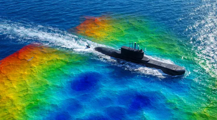
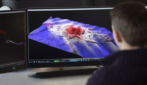
Complementing the sensing hardware is Teledyne’s software ecosystem, including CARIS HIPS and SIPS, CARIS Bathy DataBASE, CARIS Onboard360, CARIS HPD and the CARIS Mira AI Platform. These software solutions support hydrographic processing, bathymetric analysis, data fusion, chart production, visualization and automated workflow management for marine and geospatial data operations. A key technical focus of Teledyne’s geospatial architecture is the integration of lidar, sonar, visible imagery, GPS and bathymetric data within a single processing environment. The company states that this data-fusion approach enables subsea-to-sky mapping workflows while improving operational efficiency through real-time quality control, automated processing pipelines and AI-driven noise classification technologies.

The company has also expanded its topo-bathymetric mapping capabilities through technologies such as the CZMIL SuperNova system, which combines airborne lidar sensing with advanced processing workflows for simultaneous topographic and bathymetric mapping. The platform integrates full-waveform capture, high-density data collection, AI-assisted classification and coastal mapping capabilities designed for applications including shoreline monitoring, inland waterways, coral reef mapping, and marine surveying. Through the combination of advanced sensing hardware, geospatial software, AI-enabled processing tools, and integrated mapping workflows, Teledyne Imaging is developing comprehensive geospatial solutions designed to support increasingly complex land, coastal and marine data collection requirements.
About Teledyne Imaging
Teledyne Imaging is a global imaging technology organization operating under Teledyne Technologies and focused on sensing, signal generation, image processing and advanced imaging solutions across industrial, scientific, aerospace, defense, healthcare and geospatial markets. The geospatial portfolio combines the capabilities of Teledyne Optech and Teledyne CARIS, delivering integrated lidar sensors, mapping technologies, hydrographic software, bathymetric processing systems and end-to-end geospatial workflows for land and marine applications. The company’s technologies support data acquisition, processing, visualization and precision mapping operations across a wide range of commercial, government and research environments.