The April 2024 UAE floods stress-tested every traditional risk assessment model. STARPATH GLOBAL satellite imagery shows how Earth observation is transforming how agricultural insurers detect, verify, and price catastrophic flood events.
Published: April 2024 · Region: United Arab Emirates · Data: STARPATH GLOBAL · USGS
A once-in-75-year rainfall event
On April 16, 2024, a slow-moving low-pressure system originating over Sudan — amplified by an anomalous subtropical jet stream — delivered the heaviest rainfall ever recorded across the UAE. The Khatm Al Shakla station in Al Ain logged 254.8 mm in under 24 hours, roughly equivalent to two years of average annual precipitation. Dubai International Airport recorded 164 mm in a single day. Every emirate reported severe flooding, with total insured losses estimated between $2.9 billion and $3.4 billion (Guy Carpenter, September 2024).
Climate science links these extreme wet events in arid regions to a narrowing temperature gradient between the equator and the poles, which slows the jet stream and allows weather systems to stall. For agricultural insurance pricing models, this means “75-year events” may recur far more frequently than historical actuarial tables assume.
| 254.8 mm
Peak 24-hour rainfall (single station) |
$3.4B
Estimated insured loss ceiling |
75 yrs
Historical return period |
Seeing the flood boundary from orbit
The two images below are drawn directly from STARPATH GLOBAL-processed satellite data products, captured before and during the flood event. Together, they show how Earth observation translates raw satellite capture into actionable loss intelligence for agricultural insurers.

Figure 1 — STARPATH GLOBAL flood extent extraction map. Cyan pixels mark inundated parcels as classified from satellite imagery. This layer can be directly overlaid on registered farmland boundaries to calculate the flooded area ratio per insurance policy — with no field survey required.

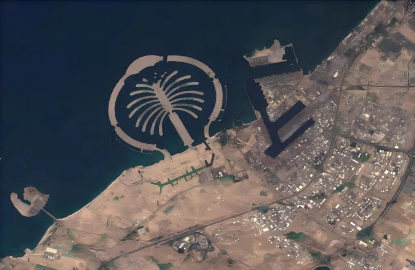
Figure 2 — Pre- and post-event satellite imagery comparison (USGS data, processed by STARPATH GLOBAL). The blue panel shows the pre-event surface baseline; the red panel shows inundated extent on April 19. The net difference between the two panels constitutes the verifiable flooded surface — a defensible basis for loss settlement and dispute resolution, with Palm Jumeirah serving as the geographic reference landmark.
From “go and measure it” to “the system shows it”
“Before, a farmer would say ‘it’s completely flooded’ and we’d have to send someone out to survey the land. Now the system runs and it’s clear — which parcel flooded, how much, and what the payout should be.”
— Business line manager, agricultural insurance operations
For agricultural insurance, precise loss assessment is not only about calculating the right number — it is equally about paying out quickly. In the aftermath of a disaster, fast access to claim settlements is the single most important factor in a farmer’s ability to resume production. By replacing manual field visits with remote sensing, and replacing experience-based judgment with data models, the claim cycle shortens dramatically and disputes decrease sharply.
Equally important, the parcel-level data and disaster records accumulated by the system are becoming a strategic asset for risk zoning and product pricing. The traditional pain point in agricultural insurance has always been “can’t see clearly, can’t calculate accurately”: What was planted on this parcel? How severe was the damage? How should payouts differ across different land plots? These questions have long depended on manual on-site inspection — slow, costly, and prone to disagreement.
The core breakthrough is this: satellite imagery builds a permanent file for every parcel of land, and data models calculate a precise account for every disaster event. By constructing a closed data loop across space, sky, and ground, remote sensing technology provides the technological foundation for accurate underwriting and claims settlement in agricultural insurance — significantly raising operational efficiency and risk management capability.
How satellite data reshapes the agricultural insurance workflow
- Real-time disaster monitoring and early warning. Multi-source satellites — optical and SAR radar — pass continuously and can penetrate cloud cover. Flood extent tracking begins during the rainfall event itself, giving insurers an objective record that predates the first claim submission.
- Precise inundation area calculation per farmland parcel. Overlaying the flood extent map with cadastral farmland data automatically calculates the flooded area ratio for every insured parcel. Region-wide loss assessment can be completed within 24–72 hours — replacing weeks of manual sampling.
- Before-and-after change quantification for settlement decisions. Pre/post-event imagery difference analysis precisely distinguishes pre-existing water bodies from newly inundated land, removing the most common source of claim disputes. The resulting dataset is an auditable evidentiary record for reinsurance arrangements.
- Historical archive-driven risk pricing recalibration. Multi-year satellite archives reveal the true frequency and spatial pattern of flood occurrence at the parcel level, enabling insurers to recalibrate actuarial assumptions for extreme rainfall in arid zones — preventing the systematic underpricing of rare but recurring catastrophe events.
Beyond floods — a scalable risk intelligence platform
The remote sensing loss assessment logic validated by the Dubai event applies equally to monsoon flooding in Southeast Asia, irrigation-zone salinisation monitoring in Central Asia, and drought assessment across the African Sahel. Across these contexts, STARPATH GLOBAL satellite imagery delivers a consistent foundation: objective, spatially precise, rapidly deployable evidence for agricultural risk decisions — at every stage from underwriting to settlement to portfolio pricing.
Explore STARPATH GLOBAL agricultural remote sensing solutionsAccess satellite imagery data product specifications, coverage areas, and integration options. View product details →