Satellite imagery can support individual tree counting when crowns are large enough, sufficiently separated and clearly visible. It is much harder to obtain a complete count in dense forests, where overlapping crowns conceal smaller trees and the ground below. The practical question is therefore not simply whether a satellite can see trees, but what it can count—and how that count has been validated.
For plantation managers, forestry teams and urban green-space planners, this distinction affects both data selection and the reliability of the final inventory. A map of tree cover, a count of visible crowns and an estimate of standing trees answer different questions.
What Does a “Tree Count” Actually Measure?
Tree cover measures the area or percentage of land covered by the canopy. Two sites can have similar canopy cover but very different numbers of trees: one may contain a few large crowns, while the other contains many smaller ones.
A visible crown count records separate crowns identified in an image. This is an observation of the upper canopy, not necessarily a count of every tree growing underneath it.
A model-estimated tree count may come from detected objects, a density model or relationships calibrated against reference plots. Some models estimate the number of trees within an area without locating every individual tree. Their output should be described as an estimate, with its validation results and uncertainty.
A field stem count records qualifying stems under a defined inventory protocol. Minimum diameter, living or dead status, and the treatment of multi-stem trees all matter. An individual plant, a stem and an image-detected crown are not always interchangeable units.
Resolution Matters, but Crown Separation Matters Too
A crown needs enough image detail to distinguish it from its surroundings and neighboring vegetation. As a simple illustration, a crown 5 meters across spans approximately ten pixels in 0.5-meter imagery, but only about one and a half pixels in 3-meter imagery. This comparison describes sampling, not a guaranteed detection threshold.
Sub-meter imagery can reveal useful crown shapes and gaps. However, nominal pixel size alone does not determine whether two trees can be separated. Image sharpness, crown contrast, viewing angle and processing also affect the result. Resampling or sharpening an image does not automatically create the missing detail needed for a reliable count.
Overlapping crowns can be merged into one detection, producing an undercount. Conversely, several bright branches or crown lobes can cause one tree to be split into multiple detections. Small or shaded crowns may disappear into the background. Seasonal foliage changes and differences in illumination can also alter how the same tree appears between acquisitions.
These effects explain why a convincing result in an open plantation cannot be assumed to work equally well in a dense, uneven-aged forest.
Where Individual Tree Counting Is Most Useful
What Published Research Actually Demonstrates
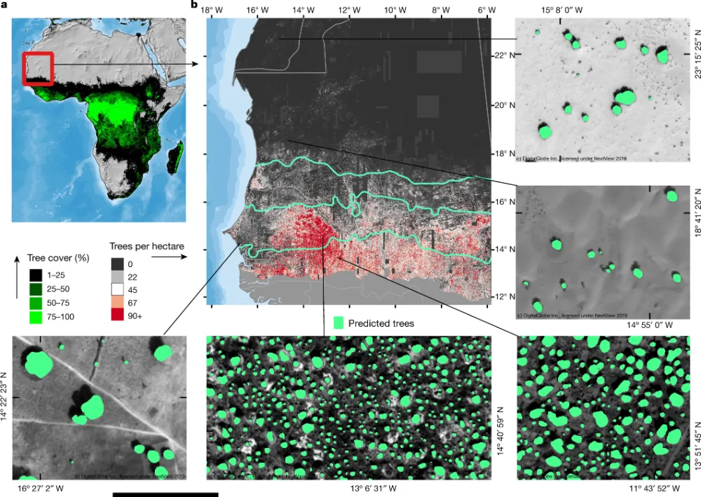
A 2023 study published in Nature Communications mapped African tree cover using PlanetScope imagery. Importantly, the researchers stated that their model did not map trees as individuals where tree cover was dense. Its continental tree-cover output should therefore not be interpreted as a complete inventory of individual trees.
To investigate missed isolated trees, the researchers compared selected, aligned scenes with an earlier tree map derived from 50-centimeter imagery. In that comparison, detections became reliable for crowns of approximately 30 square meters or larger, while about half of the smaller-crown trees were missed. These findings describe that dataset and model, not a universal minimum crown size for satellite counting.
The comparison also allowed a reference tree to be considered detected when it overlapped a predicted tree-cover object, accommodating occasional clustering. That can demonstrate the presence of tree cover without demonstrating that every neighboring tree has been counted separately.
The lesson is practical: validation of canopy area or tree presence does not automatically validate individual-tree numbers.
How to Validate a Count
A credible project should begin with a counting definition and independent reference samples. Define which trees qualify, whether the target is visible crowns or standing stems, and how trees crossing the site boundary will be treated.
For visible-crown validation, suitable reference data may include carefully annotated, finer-resolution aerial or drone imagery acquired close to the satellite date. For a stem inventory, field plots or a sufficiently detailed field inventory are needed to establish what is hidden beneath the canopy. Manually labeling the same satellite image cannot verify trees that the image does not reveal.
Validation areas should represent the site’s variation in crown size, canopy density, terrain and shadow. Keep them separate from training areas, align the datasets and use a documented one-to-one matching rule.
- Missed trees: report reference trees that have no matching detection, including their size and canopy position where known.
- False and duplicate detections: report objects without a valid reference match, separating repeated detections of one tree from other false positives.
- Merged crowns: identify detections that combine several reference trees.
- Count error: report differences by plot and landscape type, rather than relying only on the total for the entire site.
Precision describes how many reported detections are correct; recall describes how many reference trees were found. Both are necessary because omissions and extra detections can cancel out, producing an apparently accurate total with an inaccurate tree map.
A useful report should disclose sample size, reference-data type and date, matching criteria, error rates and the conditions in which performance deteriorates. If duplicate detections were not measured separately, their rate should be reported as unknown.
When Other Data Are Needed
Drone or aerial imagery can provide finer detail for small trees and tightly spaced crowns, while supplying reference imagery for a satellite-based regional survey. However, an overhead photograph still cannot reveal every tree hidden below a closed canopy.
LiDAR adds three-dimensional information about vegetation height and structure. A canopy height model can help identify tree tops, but one height peak does not necessarily represent one stem: a broad crown can contain several peaks, and suppressed trees may produce none. Detection performance still depends on forest structure, acquisition conditions and processing.
Field plots remain necessary when the objective requires stem density, diameter, species or an assessment of understory trees. Where access is limited, an initial satellite assessment can guide later sampling. Until suitable reference observations are available, the output should remain a preliminary crown count or modeled estimate with clearly stated limits.
A Tree Count Is Not a Carbon Estimate
Two sites with the same number of trees can store very different amounts of carbon. Biomass estimation commonly requires measurements or calibrated estimates of stem diameter, height and wood density, combined with appropriate allometric relationships. Converting biomass to carbon introduces additional assumptions, and ecosystem carbon accounting may also include roots, deadwood, litter and soil.
Crown measurements can contribute to a locally validated biomass model, but multiplying a satellite tree count by a fixed amount of carbon per tree does not establish a defensible carbon stock. Carbon sequestration is a further question: it requires assessing change over time, rather than counting trees on one date.
Choose the Data Around the Inventory Task
Before purchasing imagery, define whether the decision requires canopy cover, exposed crown locations, plantation survival estimates or total stem density. Then test representative areas to determine whether the proposed imagery and method can support that requirement. A small validated pilot provides a stronger basis for scaling than a visually impressive map without reference checks.
For forestry, plantation and urban vegetation projects, STARPATH GLOBAL can help you assess imagery options against your target crown sizes, site conditions and monitoring needs. Explore our satellite imagery catalog and discuss your inventory requirements with our team to select a suitable resolution and coverage plan. Teams building remote-sensing capability can also explore the Pioneer Partner Program for support from our Forward Deployed Engineers in developing workflows and staff expertise.