China launched Xiguang-4 01, also known as Wuyang Constellation Pathfinder A, on October 21, beginning in-orbit validation of a remote-sensing network designed to provide more frequent observations of low- and middle-latitude regions.
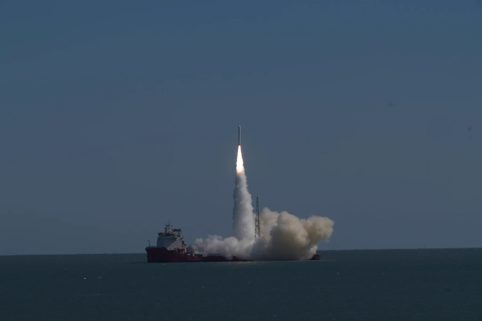
The satellite lifted off at 11:39 a.m. Beijing time aboard Galactic Energy’s Ceres-1S Y8 rocket from the Dongfang Hangtiangang launch vessel in waters off Rizhao, Shandong province. It entered its planned orbit with normal telemetry and a stable operating status. The mission introduced a new arrangement combining land-based launch command with an offshore launch.
The flight was the 24th mission of the Ceres-1 rocket family and the seventh launch of its sea-based variant, which has maintained a 100% success rate since its maiden flight on September 5, 2023.
Guangzhou University led the satellite project, with Guangdong Tianyuan Technology responsible for overall coordination and Xi’an Zhongke Xiguang Aerospace Technology Group responsible for satellite development and manufacturing.
Xiguang-4 01 is the first satellite of the Wuyang Constellation, which its developers describe as the world’s first low-inclination remote-sensing constellation. Operating in a 39-degree-inclination orbit, it combines 0.5-meter high-resolution imaging, 2-meter multispectral imaging and a 30-meter wide-swath infrared payload.
The launch brought the number of Zhongke Xiguang Aerospace satellites in orbit to 13. It is also the company’s first high-resolution optical satellite, adding detailed spatial imaging to its established hyperspectral capabilities.

The satellite on display on the ground with its solar arrays deployed.
Why a 39-Degree Orbit Matters
Many Earth-observation satellites use near-polar, sun-synchronous orbits, which support broad geographic coverage and observations under relatively consistent local solar lighting conditions. Wuyang takes a different approach: concentrating observation opportunities on the lower latitudes where its intended users operate.
Orbital inclination is the angle between a satellite’s orbital plane and the equatorial plane. In a simplified spherical-Earth model, the point directly beneath a satellite in a 39-degree-inclination orbit moves between approximately 39 degrees north and 39 degrees south. The area its cameras can actually image also depends on their swath widths and off-nadir pointing capabilities.
This belt includes southern China and extensive areas of Southeast Asia, Africa and South America. The project describes it as Earth’s “golden belt,” encompassing major population centers, economic regions and important ecosystems.
Compared with a near-polar orbit, a low-inclination orbit concentrates more of a satellite’s operating time within this latitude band. For a constellation of comparable size, that can create more opportunities to observe selected low- and middle-latitude targets.
The practical value is a denser record of change. More frequent imagery can help track flood extent, coastal water conditions, crop development and urban expansion, especially where conditions change substantially between observations.
According to the project’s published description, Xiguang-4 01 offers approximately seven times the revisit frequency of a conventional polar-orbiting satellite over its target regions. That comparison should be read in the context of the mission’s observation geometry: actual revisit intervals depend on the target location, orbit, camera swath, pointing limits and acquisition schedule. Cloud cover and illumination further determine whether an optical observation produces usable imagery.
The Wuyang project is jointly promoted by the Guangzhou municipal government, China’s State Information Center and Guangzhou University. Its aim is to build a regional space-information service system combining high spatial resolution, wide coverage and complementary spectral observations.
What the Three Imaging Payloads Contribute
The satellite’s payload specifications describe three complementary ways of observing the ground. Spatial resolution determines the scale of detail represented in an image, while spectral coverage determines which wavelengths the sensor records.
0.5-Meter Imaging: Examining Shape and Boundaries
The high-resolution camera is designed to capture fine spatial detail, supporting the interpretation of road boundaries, building outlines, field shapes and other surface features. Such imagery helps establish where a change has occurred and how much area it affects.
A 0.5-meter resolution specification does not mean every object of that size can be reliably identified. Recognition also depends on contrast, viewing angle, image quality and the surrounding scene.
2-Meter Multispectral Imaging: Comparing Spectral Responses
The multispectral camera records separate wavelength bands, providing information that can support land-cover classification and analysis of vegetation, water and soil conditions.
For example, two fields may both appear green in a conventional image while showing different responses in suitable spectral bands. Those differences can support an assessment of vegetation cover or crop condition. High-resolution imagery supplies field boundaries, while multispectral observations help characterize conditions within them.
The two specifications describe different properties: 2 meters refers to spatial resolution, while multispectral refers to the recording of several spectral channels.
30-Meter Wide-Swath Infrared: Adding Coverage and Spectral Information
The infrared payload combines 30-meter spatial resolution with wide-area coverage. Its hundred-kilometer-scale swath describes how much ground it can cover across an image; the 30-meter figure describes the spatial sampling scale.
Infrared observations can add information about reflected or emitted radiation beyond the visible spectrum. The specific applications depend on the infrared bands the instrument records, so the term “infrared” alone does not establish a particular temperature-measurement or detection capability.
Together, the payloads allow fine-detail observations and broad-area surveys during a single pass. Wide-swath imagery provides regional context, high-resolution imagery shows local detail, and additional spectral channels support interpretation.
Combining those observations requires accurate image registration so that the same locations align across datasets. Acquisition times, spectral characteristics and radiometric calibration must also be considered before differences are interpreted as changes on the ground.
A Pathfinder Before Full Constellation Deployment
Xiguang-4 01 is intended to validate the orbital configuration, assess payload performance, test new technologies and demonstrate applications before larger-scale constellation deployment.
Its in-orbit results will help connect several parts of the system: orbit selection, coordinated payload operations, satellite-to-ground communications and ground processing. Those results will inform the design and operation of subsequent satellites.
The spacecraft carries electric propulsion for orbital maneuvering and maintenance, along with a high-speed data downlink. The project describes these systems as supporting a rapid observation-to-delivery workflow, although the time users wait for a result also depends on ground-station access, processing and product generation.
Two engineering challenges are particularly relevant to the mission.
The first is structural and thermal design for a low-inclination, non-sun-synchronous orbit. Solar illumination changes with the season and orbital geometry. Engineers must account for Sun angles, eclipse periods, spacecraft attitude, equipment operating conditions, Earth’s infrared radiation and reflected sunlight while maintaining temperatures and pointing stability suitable for imaging.
The second is an electrically propelled maneuver involving an orbital-altitude change of approximately 100 kilometers within a relatively short period. This requires coordination between propulsion, attitude control and onboard power, with sufficient control of errors to protect imaging performance and mission lifetime.
The pathfinder’s significance therefore extends beyond its first images. It will test whether the complete system can repeatedly acquire, transmit and process the observations needed for an operational service.
Potential Applications Across Low-Latitude Regions
Once deployed, the Wuyang Constellation is intended to serve 15 provincial-level regions in southern China and provide frequent remote-sensing observations of low- and middle-latitude regions overseas.
Planned applications include urban management, disaster prevention and response, ecological conservation, precision agriculture, and river and lake monitoring. Internationally, the project aims to support disaster early warning, resource surveys and cross-border environmental monitoring through the Belt and Road Space Information Corridor.
The project reports that Xiguang-4 01 has been incorporated into the constellation framework of the Asia-Pacific Space Cooperation Organization (APSCO) and the data-resource framework of the Asia-Oceania Group on Earth Observations (AOGEO).
For users, the value will depend on the combination of observation frequency, usable image quality and delivery speed. More acquisition opportunities can improve the chances of obtaining timely observations, while the different payloads provide complementary information for interpreting what has changed.
Adding High-Resolution Imaging to Hyperspectral Expertise
Zhongke Xiguang Aerospace has built its business around hyperspectral satellites and remote-sensing data services, with activities spanning satellite development, constellation operations, customized payloads and data applications.
Hyperspectral and high-resolution imaging address different needs. Hyperspectral instruments divide the spectrum into many narrow, adjacent bands to record detailed spectral signatures. High-resolution cameras capture finer spatial detail, helping define shapes, boundaries and small features. The two capabilities can complement each other in an observation system.
For Xiguang-4 01, the company was responsible for integrated space-and-ground system design, satellite system studies and development, and spacecraft assembly, integration and testing. The mission extends its payload-development, integration and quality-control experience into coordinated high-resolution optical and wide-swath infrared imaging.
The project also brings together capabilities from three regions. Satellite platform integration and engineering were led from Xi’an; partners in the Yangtze River Delta contributed to sensors, optical systems and ground data systems; and Guangzhou University and Tianyuan Technology connected constellation planning, operations and applications in the Guangdong-Hong Kong-Macao Greater Bay Area.
The next step is to use in-orbit measurements to guide subsequent operational satellites. For Wuyang, successful deployment will mean turning a regional orbit design and a complementary payload combination into a consistent supply of useful imagery and analysis.
For organizations planning satellite services around a specific region or industry, orbit coverage, imaging resolution and delivery requirements need to be considered together. STARPATH GLOBAL helps international customers select suitable satellite imagery and develop customized satellite and payload projects. Discuss your requirements with our team to identify an approach that fits your application and budget.