Two satellite systems observe the same open-pit mine and offer different answers.
The multispectral satellite says: “This area appears reddish. Iron oxides may be present.” It infers material properties from differences across a handful of broad spectral bands.
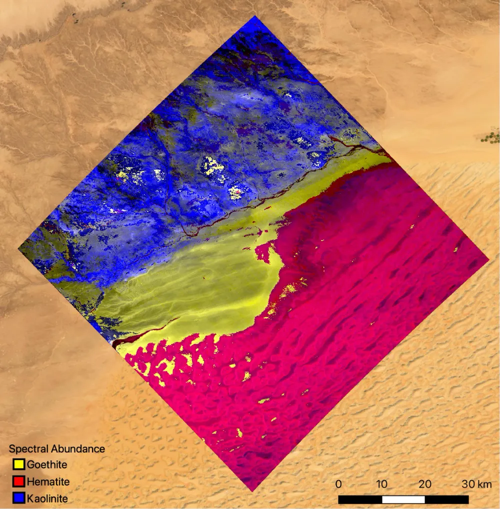
The hyperspectral satellite can go further: “The spectral signatures indicate hematite and goethite, with an associated alteration zone that can be divided into three intensity classes.” By separating reflected sunlight into hundreds of closely spaced spectral channels, it can reveal the characteristic absorption features of different minerals—their spectral fingerprints.
The distinction is between a broad indication and a more specific spectral diagnosis, although both still require suitable data, processing and validation.
A major technical divide separates the two: spectral resolution. Over the past three years, satellite developers worldwide have been working to close that gap. In 2026, however, the competition is expanding beyond band counts to include onboard computing, constellation operations and the speed at which observations become usable information.
This article examines the development of hyperspectral satellites in China and internationally, with a data access guide at the end.
1. What Makes Hyperspectral Imaging Different?
Hyperspectral imaging is more than photography with extra colors. Each pixel contains a spectrum: a sequence of measurements across many closely spaced wavelengths. Three dimensions define what a system can do.
Spatial resolution. The Dongfang Huiyan hyperspectral satellite pair offers a reported spatial resolution of 5 meters, compared with 60 meters for EMIT aboard the International Space Station—a twelvefold difference in ground sampling distance. Finer spatial resolution makes smaller features distinguishable.
Spectral sampling. Europe’s Sentinel-2 multispectral satellites observe in 13 discrete bands, resembling a set of separate color samples. The Advanced Hyperspectral Imager, or AHSI, carried by satellites in China’s Gaofen-5 series provides 330 spectral channels, recording a much more densely sampled spectrum. Closely spaced channels can preserve diagnostic absorption features that broad bands may miss.
Revisit frequency. EnMAP has a 27-day nadir repeat cycle, while off-nadir pointing can reduce the target revisit interval to about four days. The Dongfang Huiyan satellite pair is reported to support global coverage within five days. More frequent observations improve the chances of capturing change, although cloud cover and acquisition schedules still affect usable coverage.
Together, these dimensions reveal the central engineering trade-off:
Hyperspectral systems must balance spatial detail, spectral information, swath width and revisit frequency.
This helps explain why many European and U.S. public missions operate at around 30-meter resolution while commercial constellations pursue approximately 5-meter imagery. It also explains why some Chinese commercial systems emphasize swaths wider than 300 kilometers rather than spatial resolution alone.
2. Why 2026 Marks a Turning Point: Three Constraints Are Easing
The significance of 2026 is not simply the number of satellites launched. Three longstanding constraints are easing at the same time.
Onboard Computing Is Moving Processing into Orbit
Traditionally, hyperspectral observations had to be downlinked before processing could begin. Acquisition and ground processing could each take days.
New Chinese missions are testing a different approach. The Dongfang Huiyan satellite pair carries reported onboard AI computing capacity of 400 TOPS. According to the developers, onboard processing can increase data utilization from below 10% to more than 80% and reduce the time needed to deliver useful information from days or hours to minutes.
Xiguang-2 01, also known as Caiyun Hyperspectral 01, carries a water-sediment classification model. It can classify turbidity conditions in orbit and prioritize the transmission of results and relevant observations.
In a March 2026 fire-detection trial over the Mekong region, the Jilin-1 spectral satellite reportedly processed mid-wave infrared imagery at a rate of 500 square kilometers per second, with fire information reaching the ground 13 seconds later.
Onboard processing is becoming an important competitive variable, and these missions illustrate China’s growing activity in this area.
Data Access Is Becoming Easier
EnMAP, PRISMA and NASA’s EMIT provide public access to hyperspectral observations through their respective data systems.
Access conditions differ between archived imagery and new acquisition requests, but the expansion of public archives is reducing barriers to research, algorithm development and application testing.
Commercial Systems Are Raising Performance Expectations
Wyvern’s Dragonette constellation provides imagery at approximately 5.3-meter resolution. Pixxel’s Firefly satellites combine approximately 5-meter spatial resolution with 135 spectral bands.
In May 2026, Pixxel also secured a contract from the U.S. National Reconnaissance Office, or NRO, for commercial hyperspectral remote-sensing capabilities. Such contracts show that commercial hyperspectral imaging is gaining a place in government evaluation and intelligence procurement programs.
China, meanwhile, has seen a series of hyperspectral satellite launches over seven months, indicating a shift toward more frequent deployment.

The original launch timeline includes two Xiguang-series milestones: Xiguang-2 01 in July and Xiguang-4 01, which was scheduled for October. Xiguang Aerospace is pursuing multiple launches per year as it works toward its planned 158-satellite constellation.
3. International Missions: Public Programs and Commercial Operators
Outside China, hyperspectral development follows two broad models.
Public Missions: Scientific Data and Long-Term Observation
Italy’s PRISMA, Germany’s EnMAP, and the ISS-mounted EMIT and DESIS instruments are prominent examples. They provide densely sampled spectra, generally at spatial resolutions of approximately 30–60 meters, with data available through mission-specific registration and access procedures.
EMIT and DESIS are hosted instruments aboard the International Space Station rather than standalone satellites. Their approach demonstrates another route to spaceborne imaging spectroscopy: using an existing platform can reduce spacecraft development requirements, while accepting that platform’s orbit, viewing geometry and operational constraints.
Commercial Operators: Different Products and Business Models
General-purpose constellations. Wyvern, Pixxel and Kuva Space combine spectral information with increasingly fine spatial resolution, selling imagery and related analytical services.
Greenhouse-gas monitoring. GHGSat has developed a constellation focused on facility-scale emissions monitoring. Planet’s Tanager program, developed with the Carbon Mapper Coalition, also supports methane and carbon dioxide monitoring. Tanager additionally serves broader applications, including vegetation, biodiversity and surface-material analysis. Emissions monitoring has its own procurement requirements, centered on plume detection, quantification and repeat observation.
Multi-sensor operations and data services. Xplore operates XCUBE-1, its own hyperspectral satellite, alongside a broader strategy for collecting, processing and delivering satellite observations.
A significant commercial development in 2026 is the expansion into government markets. Alongside its NRO contract, Pixxel partnered with NSG UP42 to make hyperspectral imagery available through Saudi Arabia’s national Earth observation data platform.
These developments extend commercial hyperspectral imaging beyond environmental and agricultural customers into government, defense and intelligence applications—markets with different budgets, qualification requirements and purchasing cycles.
Europe is also moving toward more systematic hyperspectral services. Italy is developing a second-generation PRISMA mission, with launch targeted before the end of 2031. At the European level, the two-satellite CHIME mission is intended to provide routine hyperspectral observations and products. Published planning schedules have listed launches in 2028 and 2030, although mission schedules remain subject to revision.
AI-assisted data compression and high-rate Ka-band downlinks are part of the broader effort to make large hyperspectral datasets operationally manageable.
The direction is clear: competition increasingly concerns the entire data delivery chain, alongside sensor performance.
That objective overlaps with the approach being tested by Chinese commercial missions: process observations in orbit and transmit selected results or priority data rather than downlinking every raw measurement.

The comparison shows that most missions concentrate on visible, near-infrared and shortwave infrared wavelengths, approximately 0.4–2.5 micrometers. The Jilin-1 spectral satellite extends into the mid-wave and long-wave infrared, reaching approximately 13.5 micrometers. This gives it a different observational role from the visible-to-shortwave-infrared imaging spectrometers that dominate the comparison.
4. China: Public Missions, Commercial Constellations and Infrared Observation
China’s hyperspectral sector is developing along several distinct paths.
Public Missions Remain a Major Source of Accessible Data
The article identifies Gaofen-5 01A and Gaofen-5 02 as central public data sources. Their AHSI instruments provide 330 spectral channels at 30-meter spatial resolution, supporting large-scale access to continuous hyperspectral observations.
By the end of June 2026, Gaofen-5 01A had reportedly distributed approximately 1.187 million AHSI scenes, including 60,500 scenes in June alone.
These figures indicate substantial distribution activity. Direct comparisons with other missions require consistent definitions of scene size, processing level and distribution counts.
Commercial Route A: Xiguang Aerospace—Quantitative Observation, Onboard Processing and Constellation Scale
Xiguang Aerospace’s approach has three notable elements.
A different imaging architecture. Xiguang-2 01, or Caiyun Hyperspectral 01, uses spatiotemporally modulated interferometric spectral imaging rather than the more common grating-based pushbroom approach.
Developer-reported comparisons at an equivalent 10-meter spatial resolution show advantages over Sentinel-2 in delineating agricultural field boundaries and retrieving anthocyanin-related indicators and the MERIS Terrestrial Chlorophyll Index, or MTCI. Such comparisons remain dependent on the test conditions, processing methods and validation data.
Quantitative measurements with onboard AI. Described by its developer as China’s first quantitative hyperspectral satellite with onboard intelligent computing, Xiguang-2 01 provides 70 hyperspectral channels, 10-meter spatial resolution and an average spectral resolution of 6.5 nanometers.
It has demonstrated onboard water-sediment classification, allowing results and selected observations to be prioritized for downlink. Its stated maximum daily hyperspectral acquisition capacity is 1 million square kilometers.
Constellation deployment. By April 2026, 11 Xiguang-series satellites had reportedly been launched. The planned 158-satellite quantitative hyperspectral remote-sensing and intelligent-computing constellation comprises 108 hyperspectral satellites, 40 satellites for carbon-related monitoring and 10 supporting satellites.
The developer aims to reduce data transmission costs by more than 80% through its system architecture.
Data access is also changing. Xiguang Aerospace’s SE-Cloud platform provides registered users with self-service access to Level-2 hyperspectral sample imagery, enabling initial research and testing without a separate commercial negotiation.
Commercial Route B: Dongfang Huiyan—Onboard Computing, Wide Swaths and Coordinated Observation
Developed with the involvement of academician Li Deren’s team and Wuhan University, the Dongfang Huiyan constellation emphasizes onboard computing, wide-area collection and coordinated satellite operations.
On August 5, 2026, the Jinshan and Yinshan satellites—also known as Dongfang Huiyan Hyperspectral 01 and 02—entered orbit.
Their reported specifications include 22 precisely calibrated spectral channels, 5-meter spatial resolution, a swath wider than 300 kilometers and 400 TOPS of onboard AI computing capacity. Their developers also report substantially lower spacecraft mass than that of major European and U.S. hyperspectral missions.
Working with the earlier Dongfang Huiyan Gaofen-01 satellite, the system is intended to combine broad-area surveys with detailed observation. A wide-swath pass identifies areas of interest, followed by more focused observation of selected targets.
Assigning different roles to satellites within one constellation offers a way to manage the tension between wide coverage and detailed imaging.
A Separate Track: Mid-Wave and Long-Wave Infrared
The Jilin-1 spectral satellite combines observations in 26 discrete spectral bands. It should therefore be distinguished from instruments that record hundreds of closely spaced channels across a continuous spectral range.
Its reported spatial resolutions are 5 meters in visible wavelengths, 100 meters in shortwave and mid-wave infrared, and 150 meters in long-wave infrared.
Combined with onboard AI, this configuration supports applications such as rapid fire detection and vessel identification. Reported demonstrations include fire information delivered in 13 seconds and vessel identification within three minutes.
Its infrared coverage differentiates it from many of the visible-to-shortwave-infrared missions discussed here, rather than making it directly interchangeable with them.
5. Three Differences That Matter
Continuous Spectra Versus Discrete Bands
Whether a sensor preserves diagnostic absorption features determines which material-identification tasks it can support.
Clay and mica absorption features near 2,200 nanometers occur within narrow wavelength intervals. Broad or widely spaced bands can miss the detail needed to distinguish them.
This is a fundamental difference between a continuous imaging spectrometer such as Gaofen-5’s AHSI and a discrete-band system such as the Jilin-1 spectral satellite. The question is whether the sensor records the wavelengths and spectral detail required for the intended diagnosis.
Access Conditions and Cost Models
Public missions such as EnMAP, PRISMA and EMIT support research through accessible archives, documented products and reproducible workflows. Access to existing observations, however, differs from obtaining a new image of a particular location at a particular time.
Commercial operators offer tasking, subscriptions or other purchasing arrangements, with different coverage commitments, licensing conditions and costs.
China’s commercial sector is also developing more accessible distribution channels. SE-Cloud’s registration-based sample downloads provide one example, although sample availability should be distinguished from unrestricted access to a complete operational archive.
Processing Remains a Shared Barrier
Using hyperspectral data involves more than downloading a file and opening it in QGIS.
Noise reduction across hundreds of bands, dimensionality reduction using principal component analysis or minimum noise fraction transforms, spectral unmixing and spectral-library matching each require methodological choices.
One practical lesson is that spectra measured from fresh, dry rock samples in a laboratory may differ considerably from those of weathered surfaces in the field. An unsuitable reference library can produce a convincing-looking map with incorrect mineral classifications.
6. When Should You Use Hyperspectral Data?
Not every monitoring problem requires hyperspectral imagery.
A useful starting question is: Does the task require distinguishing materials or retrieving properties from their spectral response?
If the objective is simply to map visible change, measure an area or locate a large object, multispectral or high-resolution optical imagery may be sufficient. Hyperspectral data becomes more valuable when closely spaced spectral measurements provide information that broader bands cannot resolve.

Three Conclusions
First, competition is expanding beyond band counts. Between 2023 and 2025, much of the discussion focused on how many bands a satellite could provide. In 2026, onboard computing and constellation operations are receiving greater attention.
Figures such as 400 TOPS and plans for constellations of 158 or 258 satellites describe different aspects of that ambition. Their practical value depends on whether they improve acquisition, processing and delivery. Moving selected processing into orbit can reduce downlink requirements and shorten response times, changing both service economics and operational possibilities.
Second, China is showing momentum in engineering deployment and infrared observation, while accessible hyperspectral data services remain uneven. Commercial missions are reporting capabilities such as 5-meter imaging, 70-channel observations and 400-TOPS onboard computing, although these specifications describe different systems and cannot be treated as a single combined capability.
Gaofen-5 missions remain important sources of publicly accessible, continuous hyperspectral observations at 30-meter resolution. A broader ecosystem of routine products and straightforward data access is still developing. SE-Cloud offers an early commercial example, but archive scale, licensing and availability remain important distinctions.
Third, the decisive test is whether the full processing chain works. Onboard AI can help prioritize data and accelerate delivery. Reliable ground processing, validation and application-specific interpretation determine whether that information can support a decision.
Both are needed. For hyperspectral imaging to become a routine monitoring service, customers must be able to obtain repeatable, validated results rather than simply more spectral channels.
Choosing a hyperspectral service starts with the property you need to measure, followed by the required wavelength coverage, spatial resolution and observation frequency. For users, the practical question is which of these satellite capabilities can deliver reliable answers at an affordable cost. STARPATH GLOBAL helps customers select imagery with the spectral coverage and spatial detail their application requires, drawing on China’s growing satellite capacity to offer competitive pricing. If you are assessing whether hyperspectral data can support your monitoring needs, discuss your use case with us to identify suitable data and a workable path from imagery to results.