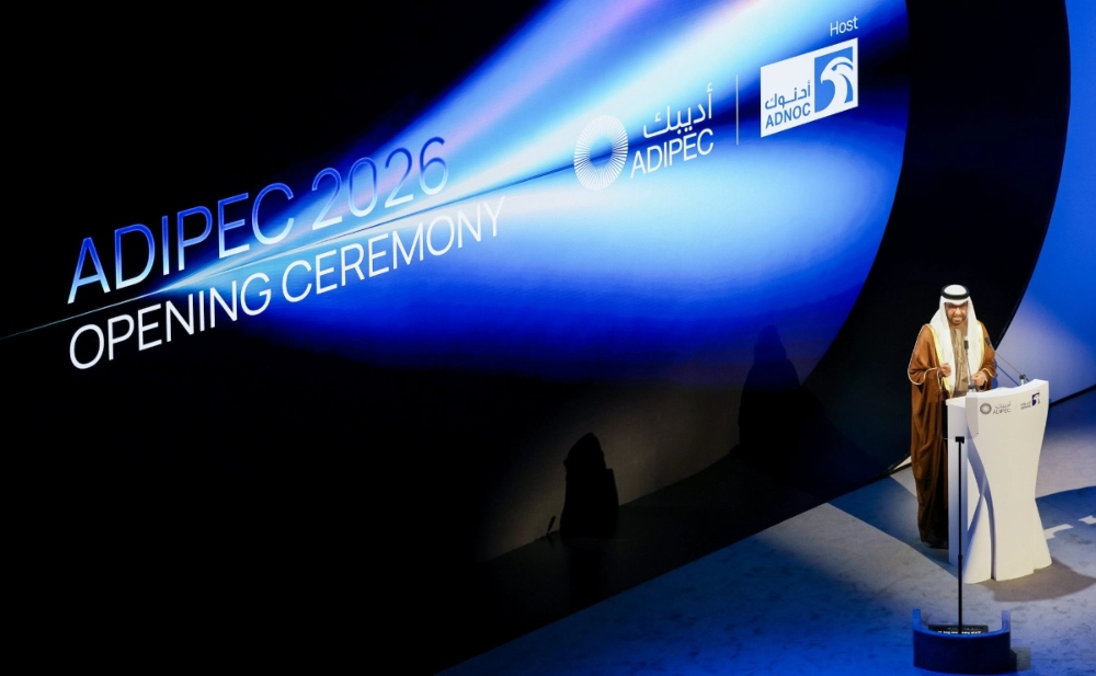
ABU DHABI, UAE — ADIPEC 2026, the Abu Dhabi International Petroleum Exhibition and Conference, was held from November 2 to 5, 2026, at ADNEC Centre Abu Dhabi. The event brought together 2,260 exhibiting companies, 30 country pavilions, and more than 1,800 speakers. With discussions spanning energy security, infrastructure resilience, artificial intelligence, digitalization, and investment partnerships, the event provided a platform for dialogue and collaboration among global energy companies, government agencies, technology providers, and industry partners.

An overhead view of the main concourse connecting the exhibition halls at ADIPEC 2026 bustling crowds, with global trade cooperation and technical discussions in full swing.
STARPATH GLOBAL participated in the event, where it showcased integrated space-, air-, and ground-based monitoring, geospatial intelligence for the energy sector, and use-case value validation. The company highlighted applications of satellite remote sensing and multi-source data analytics in the energy and infrastructure sectors and engaged with attendees on relevant technologies and potential applications.
As a major hub for the global energy industry, Abu Dhabi connects the Middle Eastern energy market with global industry, technology, and capital networks. Participating in ADIPEC gave STARPATH GLOBAL an important opportunity to gain deeper insights into regional market needs, strengthen international engagement, and explore further possibilities for applying commercial space technologies to real-world energy use cases.
From Commercial Space to Geospatial Intelligence Applications in Energy
As energy systems become more digital and data-driven, operators are exploring how satellite remote sensing and geospatial analytics can support monitoring, risk screening, inspections, and operational decisions. Assets such as pipelines, oil and gas fields, ports, and power grids often span large, complex areas exposed to construction activity, ground deformation, geohazards, flooding, and anomalous emissions.
To address the monitoring needs of energy assets across different regions, environments, and stages of operation, STARPATH GLOBAL showcased satellite data capabilities spanning optical, synthetic aperture radar (SAR), hyperspectral, and infrared data. It also introduced how wide-area satellite monitoring, multi-source data analysis, and aerial and ground-based verification can be combined in practical applications.
Featured use cases included pipeline corridor monitoring, surface deformation and geohazard analysis, oilfield methane monitoring, and monitoring of oil and gas facilities, ports, and power infrastructure. Covering early warning, incident response, and post-event analysis, these applications can support full-lifecycle risk management. Outputs may be delivered as monitoring reports, thematic data layers, and data interfaces for routine monitoring, risk screening, inspection prioritization, and follow-up verification, with formats tailored to existing GIS or asset-management environments where required.
“The applications we presented at this event focused primarily on energy and infrastructure monitoring. Through these use cases, we hope to give industry partners a clearer and more tangible understanding of the role satellite remote sensing can play, while also gathering feedback and suggestions from industry practitioners,” said Mohammad Abu Sharkh, General Manager at STARPATH GLOBAL. “These applications need to be continually refined in line with real operational requirements. We look forward to engaging with more industry partners and jointly exploring appropriate ways to apply these technologies.”

The STARPATH GLOBAL team introduces satellite products and monitoring applications for energy and infrastructure to visiting guests.
From Data Delivery to Value Validation: Integrating Technology into Business Workflows
In addition to satellite data and industry solutions, STARPATH GLOBAL introduced its Forward Deployed Engineer (FDE) service model at this year’s event.
Traditional satellite data services generally focus on imagery procurement and data delivery. The FDE model, by contrast, begins with the business challenges customers actually face. The engineering team first develops an understanding of the customer’s business objectives, asset portfolio, and existing workflows. It then identifies use cases in which satellite remote sensing can create value, designs deployable solutions, and uses real-world testing to assess their business value and return on investment.
For energy-sector customers, successful implementation often depends on more than access to satellite data. It also involves considerations such as monitoring targets, observation frequency, anomaly criteria, field verification, deliverable formats, system integration, and data security. The FDE team works with the customer to define these parameters before selecting suitable use cases for validation.
For qualifying organizations, STARPATH GLOBAL’s Pioneer Partner Program may provide preliminary opportunity assessment, identification of high-value use cases, solution design, engineering support for eligible projects, and return-on-investment assessment. The objective is to help customers evaluate technical feasibility and potential business value before committing to wider deployment or larger-scale investment.

The STARPATH GLOBAL team presents information to visiting guests.
Engaging with Industry Representatives
During the event, the STARPATH GLOBAL team introduced attendees to the main elements of its showcase and exchanged views with industry professionals on applications of satellite remote sensing and geospatial information in the energy sector.
Beyond data and technical capabilities, discussions also covered practical considerations such as monitoring frequency, deliverable formats, system integration, and application value assessment. The team also exchanged ideas with industry peers about possible follow-up activities, including further technical discussions, data trials, and use-case validation.
“ADIPEC brings together key companies and professionals from across the global energy value chain. Our on-site conversations over the past few days have given us a much clearer sense that the industry’s interest in digital monitoring and risk management is becoming increasingly focused on concrete implementation questions. They have also highlighted the potential for satellite remote sensing in the energy sector,” said Mohammad Abu Sharkh. “We hope to use this event as an opportunity to maintain dialogue with a broader range of industry partners and steadily advance technical exchanges and application validation around suitable use cases.”

The STARPATH GLOBAL team discusses satellite remote sensing applications with energy industry representatives.
Working with Industry Partners to Expand Energy Applications
By participating in ADIPEC 2026, STARPATH GLOBAL showcased how satellite remote sensing, multi-source data analytics, and field verification can be applied in the energy and infrastructure sectors. The event also enabled the company to strengthen its engagement with organizations and professionals across the global energy industry.
Looking ahead, STARPATH GLOBAL will remain focused on the practical needs of the energy and infrastructure sectors while continuing to deepen its engagement in the Middle East and other global markets. The company will advance technical exchanges, data trials, and use-case validation for pipelines, oil and gas fields, ports, power grids, and other critical infrastructure. It will also work with industry companies and partners to explore additional applications for satellite remote sensing and geospatial information.
STARPATH GLOBAL extends its thanks to all guests who visited its booth and participated in discussions during the event. The company looks forward to remaining engaged with industry partners worldwide and further expanding dialogue and collaboration in these areas.

STARPATH GLOBAL at the exhibition