Chinese researchers have developed a compact remote-sensing system capable of centimeter-level, high-resolution three-dimensional imaging while operating under tight size and power constraints, addressing a persistent payload-design challenge for satellites, unmanned aerial vehicles and autonomous machines.
China’s State Administration for Market Regulation disclosed the achievement on September 2. The research was led by the administration’s Key Laboratory of Optical Sensing and Image Metrology at China Jiliang University, working with Beihang University and other institutions.
The project targeted the difficult trade-off among low mass, limited power consumption and high-quality imaging of dynamic scenes. According to the announcement, the team made advances in three principal areas: miniaturized low-power imaging at very high resolution, high-precision modulation-transfer-function-based compensation for dynamic aberrations, and accurate 3D reconstruction in high-noise environments.
The resulting technology has independent Chinese intellectual property. Authorities described its overall performance as internationally advanced, with some elements considered internationally leading, although the announcement did not disclose the sensor architecture, operating range, power demand, payload mass or conditions under which the centimeter-level resolution was demonstrated.
Why dynamic imaging is more difficult than static observation
Producing a sharp image from a moving aircraft, satellite or robot requires more than increasing detector resolution. Platform vibration, attitude changes, optical distortion, target motion and changing illumination can all degrade the information transferred from a scene to the final image.
The modulation transfer function, or MTF, measures how effectively an imaging system preserves contrast at different spatial frequencies. High-frequency performance is particularly important for resolving small objects and fine edges. Motion or optical aberrations can reduce that performance even when the detector has a sufficiently small pixel pitch.
Dynamic aberration compensation therefore has direct implications for mobile remote-sensing platforms. Correcting image degradation as operating conditions change can allow a smaller optical system to deliver more useful detail without relying exclusively on large apertures, heavy stabilization assemblies or extensive processing after data collection.
The reported capability to reconstruct accurate 3D scenes in strong noise is also important. Three-dimensional products depend on reliable feature extraction, depth estimation or range measurements. Noise can introduce false features and depth errors, especially in low-light conditions, long-range observations, smoke, haze or rapidly changing scenes.

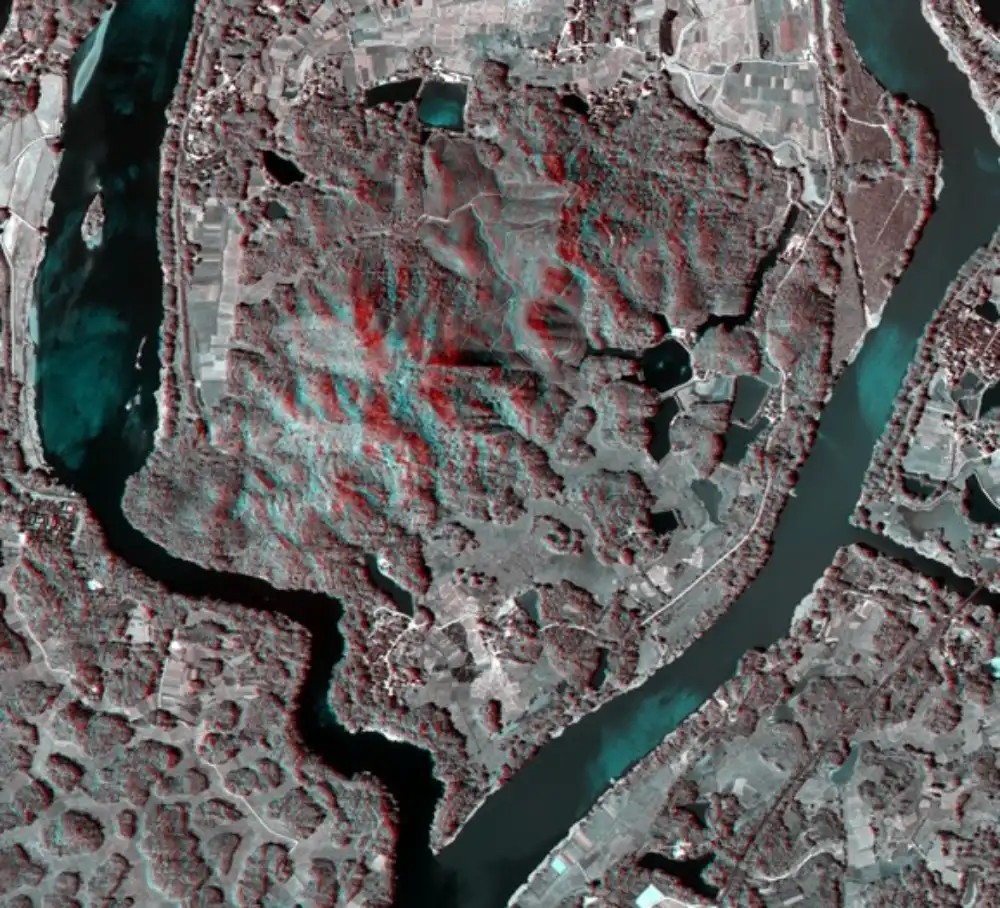
Examples of three-dimensional imaging results generated from SAR data: Monopolarimetric SAR 3D imaging data (left) and fully polarimetric SAR 3D imaging data (right).Source: Aerospace Information Research Institute, Chinese Academy of Sciences.
China has not identified whether the system uses stereoscopic cameras, structured light, lidar, computational imaging or a combination of sensing methods. The centimeter-level figure should consequently be understood as a reported spatial-performance result rather than a complete specification for a particular operational payload. Resolution alone does not establish coverage area, acquisition speed, measurement accuracy or usable range.
Smaller payloads could expand airborne and space applications
Reducing the size, mass and power requirements of an imaging payload can deliver system-level advantages. For unmanned aircraft, a lighter sensor may increase endurance or leave more capacity for communications equipment and onboard processors. On satellites, lower payload mass and power demand can simplify spacecraft-bus requirements or make advanced imaging accessible to smaller platforms.
Compact sensors still face demanding engineering qualification before operational deployment. Spaceborne versions must withstand launch vibration and shock, operate across orbital temperature cycles, maintain optical alignment and demonstrate electromagnetic compatibility with the spacecraft bus. Calibration stability is particularly important for systems using computational compensation, because performance depends on an accurate model of the optics, detector and platform motion.
For high-volume satellite production, miniaturization can also shift the integration bottleneck. A smaller payload may be easier to install mechanically, but repeatable optical calibration, geometric characterization and end-to-end image-quality testing remain essential. Manufacturers must show that performance can be reproduced across multiple units rather than achieved only by a laboratory prototype.
Processing requirements are another consideration. Algorithms that correct dynamic aberrations and reconstruct 3D scenes can be computationally intensive. Moving more processing onto the platform could reduce the amount of raw data transmitted to the ground and shorten the time from collection to decision, but it also creates demand for radiation-tolerant processors, efficient software and additional thermal management in satellite applications.
Applications extend beyond conventional Earth observation
The technology has already been applied in unmanned aircraft, aerospace systems, forest-fire prevention, security, border and coastal monitoring, industrial robotics, special-equipment inspection and smart-city operations, according to the announcement.
These markets have different imaging requirements. Forest-fire operations prioritize rapid detection, wide-area awareness and reliable performance through smoke. Infrastructure and industrial inspection depend more heavily on fine geometry and repeatable measurements. Border surveillance and urban monitoring require persistent operation under variable lighting and weather conditions.
This diversity makes configurable sensor systems commercially valuable. A single technical architecture may support different missions through changes to optics, operating altitude, processing algorithms and data products. However, users must balance spatial resolution against swath width, revisit rate, acquisition cost and the speed at which information can be delivered.
China’s expanding satellite and payload manufacturing base is bringing additional imaging capacity to the international market, including competitively priced satellite imagery and remote-sensing payload options. STARPATH GLOBAL helps customers select resolution and data products according to the actual requirements of applications such as mapping, infrastructure monitoring, agriculture and disaster response—avoiding the cost of purchasing higher-resolution imagery when a more economical product is sufficient.
Organizations without an established remote-sensing team can also contact the STARPATH GLOBAL Forward Deployed Engineering team to apply for the Pioneer Partner Program, which is designed to identify viable use cases and demonstrate measurable operational value before a commercial commitment.