Most Earth observation companies sell you data. We deliver outcomes — because we control every link in the chain from satellite manufacturing to the insight that lands on your desk.
The commercial space industry has matured to a point where the hard problem is no longer putting a sensor in orbit. The hard problem is procurement: finding, integrating, and operating the combination of hardware, launch access, ground systems, and analytics that actually solves a specific business challenge — at a price that makes sense, on a timeline that matters.
StarPath Global was built to solve exactly that problem. We are a Chinese commercial space integrator with equity stakes in manufacturing, contractual priority on launch capacity, and deep relationships across the data applications ecosystem. When a client needs something built, launched, operated, or analysed, we assemble the right combination of capabilities — and deliver.
What “Full Industry Chain” Actually Means
The phrase is common in Chinese aerospace marketing. The reality behind it varies considerably. Here is what it means in practice for a StarPath Global client.
Satellite Manufacturing
We have invested in manufacturing partners with active production lines. Our platform range spans 10kg nano-satellites through 2,000kg GEO platforms. Annual production capacity exceeds 60 satellites. Payload types include optical (0.5m panchromatic), SAR (X-band and Ku-band), hyperspectral, and infrared. Custom payload specifications are accommodated for clients with specific sensing requirements.
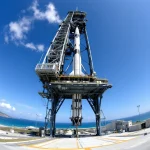
Launch Access
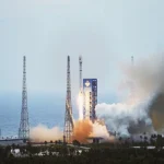
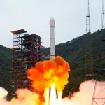
Launch capacity in China is constrained. Standard lead times run from several months to multiple years. Our contractual relationships give clients priority access that independent purchasers cannot obtain. We manage the full launch service: trajectory planning, integration scheduling, insurance, licensing, and in-orbit handover.
Constellation & Operations
We are developing the StarPath Resource & Ecology Constellation — 12 hyperspectral satellites designed for high-frequency global revisit, with decision-grade output for mining, agriculture, forestry, and infrastructure. Partners can join the constellation commercially or co-invest in dedicated capacity. TT&C network and mission control infrastructure are operated by our manufacturing partners with six ground stations across China and overseas facilities.
Data & Analytics
Raw satellite data has limited commercial value without processing. We provide end-to-end data services: L0–L4 product generation, AI-driven classification, InSAR deformation analysis, hyperspectral mineral and vegetation mapping, and sector-specific applications. Outputs are delivered via API, dashboard, or direct integration into client enterprise systems. Delivery SLAs for standard products: four hours from image acquisition.
The Hyperspectral Advantage
Our strategic focus within the constellation is hyperspectral sensing — a technology that captures hundreds of continuous spectral bands rather than the four to eight bands found on conventional satellites. The difference is fundamental.
Conventional multispectral sensors tell you that vegetation is stressed. Hyperspectral sensors tell you why — whether the stress is from nitrogen deficiency, fungal infection, water deficit, or contamination — because each of those conditions produces a distinct spectral signature, a chemical fingerprint invisible to ordinary imaging.
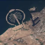
For mineral exploration, hyperspectral mapping can identify alteration zones associated with metallic ore deposits across thousands of square kilometers in a single acquisition pass — work that previously required years of ground survey. For forestry, it enables automated species classification and biomass estimation at the precision required for carbon credit verification. For agriculture, it detects disease 7–14 days before symptoms are visible to the naked eye.
Hyperspectral from orbit is not a refinement of existing Earth observation. It is a different category of intelligence — sensing at planetary scale.
EUDR: The Compliance Deadline Creating Urgency Now
European Union Deforestation Regulation
Companies exporting timber, palm oil, soy, cocoa, cattle, coffee, and rubber into the EU must prove supply chains are deforestation-free with georeferenced, dated satellite evidence. Non-compliant goods face market exclusion. The due-diligence requirement cannot be met by ground survey alone at commercial scale — satellite monitoring is mandatory in practice. StarPath Global provides EUDR-ready forest monitoring services covering deforestation detection, change alerting, and exportable compliance documentation, for both operators and their upstream supply chain partners.
This is the entry point for many international clients working with European buyers. We have structured our forestry monitoring product specifically to generate the evidence format required for EUDR due diligence — not a generic change detection map, but a dated, georeferenced, methodology-documented record that travels with the commodity through the supply chain.
How Engagements Work
Define the intelligence requirement
We begin with the decision you need to make, not the sensor you should buy. Whether the objective is EUDR compliance, mineral prospecting, infrastructure risk management, or crop yield forecasting, we map your requirement to the appropriate combination of sensors, coverage parameters, and analytical products.
Match to existing assets or scope new hardware
For many requirements, existing constellation capacity from our partners — SAR, optical, infrared — is sufficient and can be deployed within days. Where requirements exceed existing capabilities, we scope a custom satellite or dedicated constellation share, with manufacturing and launch timelines quoted concretely.
Deliver validated, actionable products
Outputs are validated against ground truth before delivery. We do not transfer raw data and consider the obligation discharged. Our team works with clients to integrate the output into their operational workflows — GIS systems, asset management platforms, reporting frameworks, or the custom dashboard format their decision-makers actually use.
Build toward long-term monitoring capability
The value of Earth observation compounds over time. A single acquisition answers a question. A time series of consistent acquisitions reveals trends, anomalies, and change — the information needed for risk management and planning. We structure engagements to build toward the archive that gives clients durable intelligence advantage.
Why China, Why Now
China’s commercial space industry has reached a level of technical maturity and cost efficiency that is not yet fully reflected in the perception of international buyers. The same supply chain that has put more than 500 commercial satellites in orbit in the last five years — at costs significantly below comparable Western programs — is accessible through StarPath Global as a structured, accountable partner for international clients.
We are not a reseller of Chinese space capacity. We are a company built to give international clients the ability to specify, commission, and operate Earth observation capabilities using Chinese industry — with a single point of accountability, English-language engagement, and contracts structured for international commercial norms.
Our team spans satellite engineering, remote sensing data science, commercial development, and international program management. We understand what governments and large enterprises need from a space partner: reliability, transparency, and the ability to deliver on commitments made at the proposal stage.