What does computing in space actually change for people on the ground? Crop insurance offers a practical starting point. Satellite imagery, artificial intelligence and digital field records are changing how insurers identify farmland, assess damage and help farmers reduce losses.
The value becomes clearer when individual projects are examined in detail: where the data comes from, what AI does, how workflows change and where the savings emerge. Two projects in China show how this works for something as ordinary—and economically important—as insuring a field of wheat.
After a Hailstorm: An Old Problem Meets a New Workflow
Consider a farmer filing an insurance claim after a hailstorm. Under the traditional approach, loss adjusters visit fields individually, measure the affected area, estimate damage, take photographs and complete paperwork. Damage assessments can take more than ten days, with payment arriving later.
Farmers face an anxious wait. Insurers face high labor costs, inconsistent measurements and disputes over basic questions: How much land was planted? Which fields belong to which policyholder?
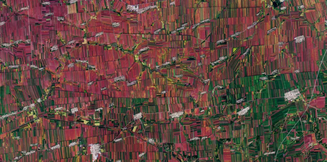
Digital tools are changing that process. Farmers can view satellite imagery of their fields on a phone. After a disaster, a system compares imagery captured before and after the event to identify affected parcels and estimate the severity of damage.
An August 18, 2026 report in Anhui Daily described a process in which satellite observations and drone surveys help establish the extent of damage and accelerate payment. Behind that simpler experience is a substantial reorganization of the insurance workflow.
Case Study 1: Xingtai Gives Every Field a Digital Identity
In Xingtai, Hebei Province, an agricultural insurance data project began by establishing a reliable data foundation. Promoted by the municipal data bureau and developed by the Xingtai branch of Ping An Property & Casualty Insurance Company of China, Ltd., the project reportedly won second prize in the Hebei regional competition of the “Data Elements ×” contest, according to September 2026 reporting.
Its first step was to build a collection network combining five complementary sources:
- Satellite imagery at 0.5-meter resolution: broad coverage across the project area.
- Drone surveys at 0.1-meter resolution: finer detail to resolve field boundaries that satellite imagery cannot clearly distinguish.
- Meteorological monitoring: records of when hazardous weather occurs and how severe it is.
- Ground surveys: reference data to calibrate and validate AI models.
- Manual verification: checks for disputed parcels and exceptional cases.
Each field receives a unique identifier under a “one parcel, one code” system. This apparently modest step is essential: satellite observations must correspond to the correct parcel, farmer and insurance policy. Without those connections, subsequent analysis cannot reliably support underwriting or claims.
The identifiers create a common reference for questions about planted area and parcel ownership, helping reduce the disputes that slow traditional workflows.
AI then supports three tasks: identifying crops, assessing disaster damage and pricing risk. Crop identification and damage assessment inform whether a claim is covered and how much should be paid. Risk pricing informs the premium charged. Together, they support both sides of the insurance business.
Case Study 2: Bortala Moves Insurance Work onto a Map
A similar approach has been applied in Bortala Mongol Autonomous Prefecture, Xinjiang. The pilot, located in Tuoli Township in Jinghe County, also involved a local Ping An P&C operation. Its use in two regions thousands of kilometers apart suggests that this approach could support a repeatable operating model.
The Bortala system combines satellite remote sensing, drone oblique photography and ground-based Internet of Things sensors. High-precision BeiDou positioning aligns the information on a shared map.
For each parcel, the system connects eight categories of information: location, area, landholder, crop type, grower, damage location, compensation recipient and compensation amount.
That foundation supports three map-based workflows:
- Underwriting: Farmers confirm their parcels through the Ainongbao app, reducing reliance on field staff to identify boundaries.
- Monitoring: Satellite observations, described in the pilot as having a three-to-five-day revisit interval, help AI track crop conditions and support warnings and loss reduction.
- Claims: AI-assisted damage assessment allows adjusters to complete more work from a digital map, reducing the need for repeated field visits.
What Does “Revisit” Mean?
A revisit interval is the time between successive observation opportunities over the same area by a satellite or constellation. The Bortala case describes an interval of three to five days; this is specific to the observation service used, rather than a universal characteristic of low Earth orbit satellites.
More frequent observations improve the chances of capturing changes around a disaster. In everyday terms, revisit describes how often the satellite patrol returns to check on a field.
The Next Question: Where Does the Computing Happen?
These cases show the value of combining satellite observations, AI and connected insurance records. They do not, by themselves, establish that the analysis was performed aboard satellites. That distinction matters when discussing the additional potential of computing in space.
In a conventional workflow, satellites collect imagery and transmit it to ground stations, where servers process it. The volume of observations, available downlink bandwidth and time within range of ground stations can constrain how quickly information becomes available.
A September 24, 2026 report in Guangming Daily cited a scenario in which less than one-tenth of observation data could be returned to the ground, with more than 90% discarded before downlink. Such figures depend on the mission and operating conditions and should not be treated as a universal rate for Earth observation satellites.
Onboard processing moves selected analytical tasks into orbit. A satellite could identify crop types, flag possible damage or prioritize affected areas, transmitting compact results first and retaining imagery for selective downlink. Depending on the task and output, the original article describes potential reductions in transmitted data to one-tenth or even one-hundredth of the original volume.
For crop insurance, the opportunity is to shorten the path from observation to action: earlier warnings before a disaster, better support for loss reduction during an event and faster assessment afterward. The benefit depends on whether the results reach farmers and insurers in time to change a decision.
Why Major Insurers Are Investing
Major insurers are treating these capabilities as an investment priority. China Pacific Property Insurance Co., Ltd. reportedly allocated more than RMB 50 million in dedicated research and development funding in 2025 to its Huizhinong agricultural risk management platform.
By the first half of 2026, its foundational parcel database covered 69 townships, 1,256 villages and 377,000 farming households. In 2025, the insurer provided more than RMB 637.3 billion in risk coverage across over 16.5 million farming-household instances of service.
Two examples illustrate the operational value. After wheat covering approximately 10,000 mu, or 667 hectares, was damaged in Zaoyang, Hubei Province, satellite remote sensing and parcel records helped the insurer assess losses and pay more than RMB 3.3 million in claims.
A disclosure published in September 2026 also described how the insurer identified areas suitable for emergency harvesting before a typhoon affected Binyang, Guangxi, helping avert more than RMB 5 million in economic losses. The disclosure named the storm as Maysak.
The two figures represent different benefits. The RMB 3.3 million payment illustrates faster claims handling. The more than RMB 5 million in avoided losses illustrates an opportunity to intervene before damage becomes an insurance claim.
This approach is known as risk reduction services. Insurers use observations and warnings to help policyholders take protective action before losses occur. When those interventions work, farmers retain more of their harvest and insurers can reduce claims costs.
From Remote Sensing Data to a Recognized Data Asset
Guoyuan Agricultural Insurance in Anhui has taken the approach further. According to an August 18, 2026 report in Anhui Daily, remote sensing supported underwriting for 50.53% of its total insured area in Huainan.
After cornfields were damaged in Jieshou, a drone surveyed 100 mu, approximately 6.7 hectares, in ten minutes—a task that would traditionally take at least two hours on foot.
The company also obtained what the report described as China’s first agricultural insurance data asset property rights registration certificate.
That development points to another dimension of satellite data’s commercial value. Beyond supporting individual underwriting and claims decisions, a structured dataset can become a formally registered asset that may be valued and used in commercial arrangements.
Registration, however, does not automatically make a dataset eligible for balance-sheet recognition, trading or use as loan collateral. Those outcomes depend on the applicable requirements and the specific transaction.
Separately, Guoyuan reported that its agricultural insurance and credit model served 36,000 households in the first half of the year and facilitated RMB 20.67 billion in credit, up 470.8% year on year. This illustrates the broader connection between insurance information and agricultural finance, without establishing that the registered dataset itself secured those loans.
Key Figures and Sources
- Xingtai project: Underwriting review shortened from seven days to two hours; claims damage assessment from 15 days to three days; weather warnings issued 72 hours ahead; regional disaster loss rate reduced by more than 20%. Xingtai Municipal People’s Government website, September 10, 2026.
- Bortala pilot: Policy processing shortened from four hours to ten minutes; damage assessment from seven days to three hours; claim closure from 110 days to 48 days; fraudulent application detection rate increased by 45%. Bortala Digital Development Bureau, September 2026.
- CPIC Property’s Huizhinong platform: More than RMB 50 million in R&D funding in 2025; parcel records covering 1,256 villages and 377,000 farming households; RMB 637.3 billion in insurance coverage; more than RMB 3.3 million in Zaoyang claims payments; more than RMB 5 million in avoided losses in Binyang. Public disclosures published in September 2026.
- Guoyuan Agricultural Insurance: Remote sensing supported underwriting for 50.53% of its insured area in Huainan; registration of an agricultural insurance data asset; RMB 20.67 billion in credit facilitated through its agricultural insurance and credit model. Anhui Daily, August 18, 2026.
- Satellite data downlink constraints: The claim that more than 90% of observation data was discarded before reaching the ground was cited in Guangming Daily, September 24, 2026, and requires mission-specific context.
These figures are compiled from the public information identified above.
The Practical Takeaway
The value of satellite intelligence becomes tangible when it helps a farmer receive compensation sooner, gives an insurer a clearer picture of damage or provides enough warning to save a crop before it is lost. Onboard computing could shorten that chain further, but the business outcome depends on the complete workflow—from observation and parcel records to decisions on the ground.
For insurers and agricultural organizations building that workflow, selecting imagery with the right resolution, observation frequency and cost is a practical first step. STARPATH GLOBAL combines global satellite resources with monitoring and analytical services to match data to the decision at hand. Discuss your needs with our team to explore a suitable approach to crop monitoring, damage assessment and agricultural risk management.
Further Reading: How Satellite Data Supports Agricultural Insurance and Lending