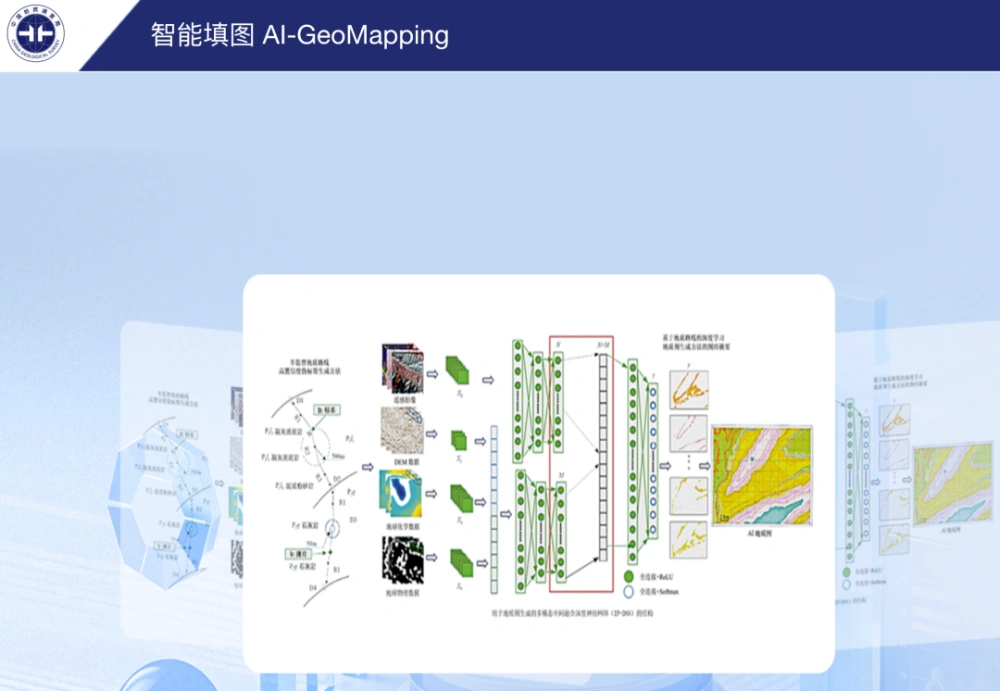
China’s AI-GeoMapping system has guided 400 square kilometers of 1:50,000-scale regional geological mapping in northern Alxa, Inner Mongolia, where fused remote-sensing, aeromagnetic and geochemical data helped field teams identify concealed intrusions, faults beneath sediment cover and new mineral-prospecting clues. The Hohhot Natural Resources Comprehensive Survey Center of the China Geological Survey reported on Sept. 24 that the Aogan Aoribuge demonstration project had defined 13 lithostratigraphic mapping units, distinguished five phases of intrusive activity and discovered a copper–iron mineralized alteration zone north of Yagan.
China’s Ministry of Natural Resources made the system’s global debut on Sept. 11 at the 28th China Mining Conference and Exhibition in Tianjin. Developed by the China Geological Survey, the platform is designed to support pre-survey research, field data collection, automated map generation and final map compilation. The Alxa project demonstrates how those functions can be applied in desert terrain where direct geological observation is constrained.
The project area lies in the Gobi Desert of northern Alxa, where extensive Quaternary cover leaves bedrock exposures scattered and makes concealed geological bodies and fault structures difficult to identify at the surface. These conditions increase the workload required for conventional geological mapping and limit the efficiency of uniformly spaced field traverses.
During the pre-survey phase, the team used AI-GeoMapping to integrate remote-sensing imagery, aeromagnetic measurements and geochemical exploration data into a predictive geological map. Fieldwork then followed a sequence of sparse initial traverses, AI-directed investigation and denser verification in priority areas.
This workflow replaced blanket, evenly distributed route planning with targeted field checks. It reduced low-value reconnaissance while directing geologists toward areas where multiple datasets indicated potentially important geological features.
The system’s interpretations helped delineate an ore-bearing horizon in the Lower Cretaceous Bayingebi Formation and the contact between mylonitized monzogranite and marble of the Beishan Group. Across an extensive area covered by Mesozoic and Cenozoic deposits, the system also identified evidence of a possible concealed intrusive body. A subsequent field inspection found monzogranite exposed in a gully.
In another case, the team interpreted a linear fault hidden beneath Quaternary cover and confirmed its presence through field investigation. The result provided additional evidence for refining the subdivision of the Beishan Group and interpreting the structure of the Yagan metamorphic core complex.
The operational value of the approach comes from combining datasets that observe different geological signals. Remote sensing can reveal surface spectral, textural and geomorphic contrasts, while aeromagnetic surveys can indicate magnetic sources and structures beneath sediment cover. Geochemical surveys add information about anomalous elemental distributions that may be associated with particular rock units or mineralization.
Combining these layers allows geologists to prioritize areas where sparse outcrops make any single dataset inconclusive. The resulting predictive map nevertheless represents a set of geological hypotheses rather than a replacement for direct observation.
The China Geological Survey said AI-GeoMapping integrates more than 150 data-processing and interpretation algorithms with geological, geophysical, geochemical and remote-sensing datasets. The system has been tested across nearly 100 1:50,000-scale map sheets in eight Chinese provincial-level regions and promoted for application in Morocco, Saudi Arabia, Laos, Peru, Rwanda and Tanzania.
The agency reports overall geological-body recognition accuracy exceeding 90% and efficiency gains of more than 50% in data processing, integrated analysis and geological map compilation. Those are system-wide figures rather than measurements specific to the Aogan Aoribuge project, which reported reduced fieldwork but did not quantify the savings.
Project personnel emphasized that AI-GeoMapping is not intended to replace field geologists. The team is applying an “AI prediction plus field verification” model under which every interpreted feature must be checked on the ground before being incorporated into the geological results. That requirement is particularly important in covered terrain, where similar geophysical or remote-sensing signatures can have several possible geological explanations.
The project will next combine further AI-GeoMapping analysis with measured geological sections and laboratory sample testing to refine geological-unit boundaries. The team also plans to investigate relationships among tectonic activity, magmatism and mineralization, with the aim of supplying higher-quality baseline geological data for China’s latest mineral exploration initiative.
For mining and geological survey teams developing similar data-driven workflows, China’s expanding satellite capacity allows STARPATH GLOBAL to provide international clients with competitively priced imagery while matching spatial resolution, spectral coverage and revisit frequency to the actual exploration task, avoiding unnecessary data costs. Organizations can review the satellite imagery catalog or contact our team to discuss data availability and project requirements. Teams without previous remote-sensing experience can also apply to the Pioneer Partner Program, where Forward Deployed Engineers work directly with customer teams to assess use cases, validate workflows and build operational capability before any commercial commitment.