Disaster preparedness starts well before an emergency unfolds. The goal is to get people moving while there is still time to protect lives, crops and property.
Every extra day of warning changes what can be saved. Three hours may leave time for evacuation; three days can also allow farmers to harvest crops early, reinforce greenhouses and position emergency supplies. But where does that 72-hour warning window come from?
Case Study 1: How Xingtai Generates 72-Hour Warnings
In Xingtai, China, an agricultural insurance initiative offers more than underwriting and claims settlement: it can send weather-related disaster warnings 72 hours in advance. Associated risk reduction services have reportedly helped reduce the regional disaster loss rate by more than 20%, according to the Xingtai Municipal People’s Government website in September 2026.
How is that lead time achieved? The underlying approach combines several sources of information. Satellite remote sensing shows current conditions, while meteorological monitoring indicates how those conditions may develop. Bringing the two together gives AI a basis for assessing potential disaster impacts. Instead of simply saying, “Heavy rain is expected tomorrow,” the aim is to answer more practical questions: Which sections of a 20-hectare cornfield could flood? How much production might be lost? Would harvesting early be worthwhile?
The distinction is between a general weather forecast and field-level risk information. The same rainfall can have very different consequences for crops on a slope and crops in a low-lying field. Once the assessment identifies specific plots, it can support specific actions: harvest here, improve drainage there, reinforce structures elsewhere.
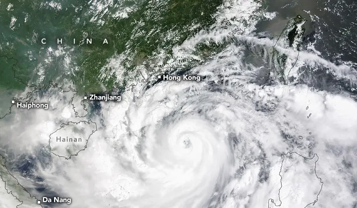
What happens after a warning is issued matters just as much. According to information disclosed in September 2026, China Pacific Insurance (CPIC) used satellite data to identify areas suitable for early harvesting before Typhoon Maysak affected Binyang, Guangxi, helping avert more than RMB 5 million in economic losses. A warning creates value when someone acts on it.
Case Study 2: From 90 Minutes to Minutes—Accelerating the Warning Workflow
The 72-hour figure describes warning lead time. A separate measure is how quickly the warning product itself can be generated.
The conventional workflow described in the cited reports takes approximately 90 minutes: satellite observation, data downlink, ground processing, warning issuance and distribution. During that interval, a short-lived severe storm may already have struck. Reports about Xiguang-2 03, launched in July 2026, describe a reduction in this workflow from approximately 90 minutes to a matter of minutes through onboard processing: observations are analyzed in orbit, and the resulting information is transmitted to the ground.
The two measures address different needs. Lead time determines how much preparation is possible; processing speed determines how quickly new information becomes available. For hazards such as typhoons, a 72-hour outlook can support advance planning. For rapidly developing severe convection, generating information within minutes can be critical.
Satellite and AI Disaster Risk Reduction: Reported Results
- 72 hours: Lead time for weather-related disaster warnings in Xingtai.
- 90 minutes → minutes: Reported acceleration of the warning workflow associated with Xiguang-2 03.
- More than 20%: Reported reduction in the regional disaster loss rate in Xingtai.
- Over RMB 5 million: Economic losses reportedly averted by identifying areas for early harvesting before Typhoon Maysak.
- RMB 90 million: Cumulative payouts over ten years under weather index insurance for Jingshan tea.
- Field-level assessments: Different risk conclusions for sloping and low-lying fields exposed to the same rainfall.
Sources: Xingtai Municipal People’s Government website, September 10, 2026; July 2026 reporting on Xiguang-2 03; September 2026 disclosures concerning CPIC’s “Huizhinong” agricultural risk management solution and the Jingshan tea insurance case.
The Economics of Prevention: Two Ways to Spend the Same Money
Why are insurers interested in early warnings? Consider two ways of spending money on the same typhoon. Before the event, issuing warnings and organizing early harvesting might involve coordination costs of several hundred thousand yuan. After the event, assessing damage and settling claims could involve payouts of millions or tens of millions. The reported RMB 5 million saved in the Maysak case illustrates the potential value of acting before losses occur.
Another tool is weather index insurance. Instead of basing every claim on an individual field inspection and loss assessment, a policy specifies an objective weather indicator, such as rainfall, wind speed or accumulated temperature. A qualifying index reading triggers a payout under the policy terms.
Weather index insurance for Jingshan tea in Zhejiang has reportedly paid out RMB 90 million over ten years. The approach can simplify claims handling because payment depends on the agreed index rather than a separate assessment of each farmer’s losses. Long-term weather records, including satellite observations where applicable, can support the risk analysis behind such products.
Prevention aims to avoid losses; compensation pays for losses that have already occurred. Earlier warnings and faster analysis can give insurers and their customers more opportunities to intervene before damage becomes a claim.
The Limits: Early Warning Cannot Do Everything
First, these examples concern weather-related hazards. Typhoons, heavy rainfall, drought and cold spells are important applications for satellite observations and AI. Earthquakes involve different physical processes, and no satellite system can currently provide reliable earthquake predictions.
Second, false alarms carry a cost. Repeated warnings that fail to materialize can erode trust and make people less likely to respond to the next alert. Filtering false alarms is therefore as important as generating warnings quickly. Achieving accuracy can be harder than achieving speed.
Third, the last mile depends on people. Delivering an alert to a phone does not guarantee action. Older residents living alone, the cost of evacuation and the belief that a disaster will pass without harm can all prevent a response. Technology can support timely information delivery, while local organizations still need to help people understand the risk and act.
Industry Term: Risk Reduction Services
In insurance, risk reduction services means intervening before a loss occurs through warnings, inspections and engineering measures, rather than focusing solely on compensation afterward. The objective is to prevent damage or reduce its severity, lowering losses for customers and claims costs for insurers.
Put simply: the most useful support may be the support that helps a customer avoid needing to make a claim.
Key Data Points
① Xingtai: weather-related disaster warnings up to 72 hours in advance and a reported reduction of more than 20% in the regional disaster loss rate (Xingtai Municipal People’s Government website, September 10, 2026).
② Xiguang-2 03: a reported reduction in the weather warning workflow from approximately 90 minutes to minutes (July 2026 reporting).
③ CPIC: more than RMB 5 million in economic losses reportedly averted through early identification of harvestable areas before Typhoon Maysak; RMB 90 million in cumulative payouts over ten years under Jingshan tea weather index insurance (September 2026 disclosures).
These figures summarize the publicly reported cases cited above.
The best outcome is to prevent a hazard from becoming a loss—and warning lead time creates more opportunities to do that.
Turning that extra time into action requires information about where damage could occur and what is at risk. STARPATH GLOBAL’s emergency management solutions combine satellite and weather data to support typhoon warnings, post-disaster damage monitoring and insurance loss assessments. We also integrate SAR imagery with terrain and hydrological data to help identify landslide and subsidence risks. Our team manages satellite tasking, data sourcing, processing, quality control and delivery, helping clients focus on preparedness and response.