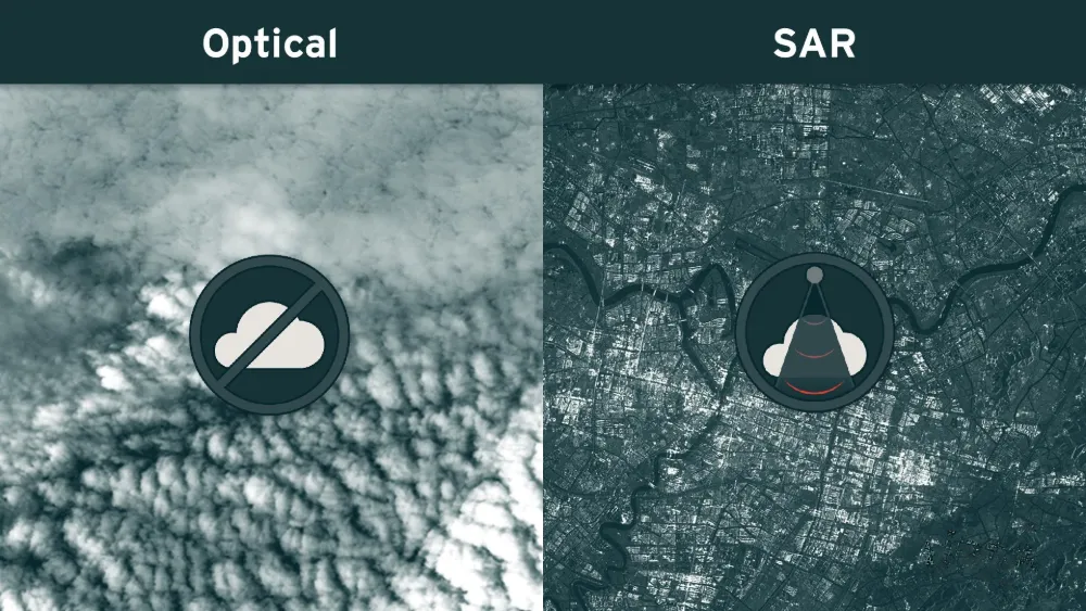
A satellite may pass over a mine, port or infrastructure corridor on schedule and still produce no usable optical view of the site. Clouds can hide the ground, while cloud shadows and haze can make visible areas unsuitable for reliable analysis. Synthetic aperture radar (SAR) can maintain observations through cloud cover and darkness, but it measures a different kind of information. Whether it helps depends on the business question, the target and the imaging geometry.
For monitoring teams, the useful distinction is between an opportunity to collect an image and an observation that can support a decision.
Why is there no usable image for a particular date?
An empty date in a monitoring dashboard can have several explanations. The site may not have been acquired; an acquired image may still be awaiting processing or delivery; or the image may have failed the project’s quality checks. These situations need different responses: another acquisition, more time, or a different sensor.
Optical land-imaging sensors measure reflected sunlight in visible and infrared bands. Thick clouds obscure the surface signal. Thin clouds and haze can alter it, and cloud shadows reduce illumination even where the ground is not directly covered. Copernicus processing therefore identifies clouds, cirrus and cloud shadows separately. Masking these areas excludes unreliable observations; it does not reveal the ground beneath them.
Scene-wide cloud percentages also need care. Consider an illustrative image with only 10% cloud cover: if that cloud sits directly over the mine being monitored, the image may be useless for that task. A much cloudier scene could still provide a clear view of the same mine.
The relevant quality measure is visibility over the area of interest, including the critical assets within it.
This is why a short revisit interval cannot be treated as a guaranteed reporting interval. Repeated passes create more opportunities, but persistent cloud can interrupt a sequence of usable optical observations. An image that is clear enough to locate a large building may still be unsuitable for measuring a subtle spectral change.
Can monitoring continue through clouds?
Often, yes—if the required indicator can be measured with SAR.
SAR transmits microwave pulses and measures the returning signal. It supplies its own illumination, so it can operate at night, and its wavelengths allow it to observe the surface through ordinary cloud cover. This makes radar valuable when optical observations are repeatedly interrupted.
However, removing the cloud obstruction does not remove acquisition scheduling, resolution requirements or delivery time. SAR is also a sequence of observations, rather than a continuous live view.
A project should therefore ask a specific question: can radar detect the change we need to act on? Monitoring vessel presence, surface disturbance and ground displacement involves different data and analysis requirements.
Why a radar image can be difficult to interpret
A bright radar pixel indicates a strong return toward the sensor. It does not mean that the object is bright in visible light. Radar response depends on surface roughness, moisture, structure, wavelength, polarization and viewing angle. Buildings can produce strong returns through reflections between walls and the ground; smooth water often appears dark because it reflects energy away from the sensor.
These properties make SAR useful, but they also create ambiguity. A change in radar brightness can reflect wetter soil or a different viewing angle rather than new construction. Comparisons should use compatible acquisition settings and account for environmental conditions.
SAR’s sideways view introduces additional problems:
- Foreshortening: slopes facing the radar appear compressed.
- Layover: returns from elevated features overlap those from lower features, complicating their separation.
- Radar shadow: terrain or structures prevent the radar from illuminating an area.
These effects matter around steep mine walls, hillsides and tall industrial structures. Terrain correction improves spatial positioning, but it cannot recreate measurements from a surface hidden in radar shadow or fully separate overlapping returns from one view. Another viewing direction may help. SAR also contains speckle, a granular pattern that can complicate interpretation of small features.
What this means for mines, ports and infrastructure
The following examples are practical implications of the sensor characteristics, rather than guarantees of performance at every site.
Mines: disturbance and displacement are different tasks
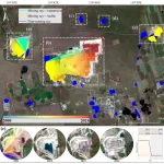
Detecting an altered surface from radar intensity is different from measuring movement with InSAR. InSAR uses phase differences between compatible acquisitions to estimate changes in distance between the surface and the satellite.
Copernicus identifies mining-related subsidence assessment as a radar application. Yet active excavation, vegetation changes or other changes in scattering can reduce the consistency required for displacement analysis. Suitable points around a mine may support useful measurements while parts of the working pit do not.
Ports: seeing a vessel is different from identifying it
ESA documents SAR ship detection and the value of combining detections with Automatic Identification System (AIS) information. Radar can reveal a vessel even when it is not broadcasting AIS, but a detection alone does not establish its identity or explain its activity.
For port monitoring, the acquisition time also matters: a satellite image is a snapshot. A vessel that arrives and departs between observations may never appear in the image sequence.
Infrastructure: movement is an indicator requiring interpretation
InSAR can help identify displacement trends around infrastructure. Its measurements are along the satellite’s line of sight; a single viewing direction does not provide a complete three-dimensional motion estimate. Atmospheric effects and loss of signal consistency can also affect the result.
Ground movement near a pipeline or railway can justify inspection. It does not, by itself, prove a leak, a damaged component or an unsafe structure.
Can SAR completely replace optical imagery?
For a defined indicator, SAR may become the primary source. For a broader monitoring service, optical and radar observations usually contribute different evidence.
Optical imagery provides familiar visual context and spectral measurements. SAR adds sensitivity to scattering properties and, with appropriate processing, displacement. A radar image is therefore not a cloud-free optical photograph.
Likewise, a cloud-free mosaic assembled from several dates is not necessarily an observation of the whole site on one date. Model-generated optical reconstructions are estimates, and should be labelled accordingly when used in operational reporting.
Choose data around the decision
Before selecting a sensor, define the smallest change that matters, the required update window and the evidence needed to act. Then check actual archive coverage, visibility over critical assets, suitable radar geometry and the availability of comparable observations.
Reporting should distinguish an observed change, no detected change and insufficient evidence. A cloud-covered asset cannot support a confident “no change” conclusion.
For projects facing repeated cloud gaps, STARPATH GLOBAL can help select optical and SAR data around the monitoring task, target scale and required update interval. Our imagery catalog provides a starting point for exploring data options; discuss your site and monitoring requirements with our team to assess a suitable combination of coverage, resolution and analysis. Teams building their first remote-sensing workflow can also explore the Pioneer Partner Program for support from our Forward Deployed Engineers.