China’s 134.2-kilometer Pinglu Canal officially opened to navigation on September 16, 2026, creating a direct waterway between the Xijiang River system and the Beibu Gulf. Satellite imagery released by the China Centre for Resources Satellite Data and Application provides a corridor-wide view of the RMB 72.7 billion project and records the construction of new channels, bridges and navigation hubs since work began on August 28, 2022.
The Pinglu Canal is the first river-to-sea canal planned and built at the national level since the founding of the People’s Republic of China. It is also a backbone project of the New International Land-Sea Trade Corridor, designed to provide Guangxi and other parts of southwestern China with a shorter waterborne route to the coast and Southeast Asian markets.
The canal begins at the Pingtang River estuary in Hengzhou, part of Nanning, runs south through Luwu in Qinzhou’s Lingshan County and follows the Qinjiang River to the Beibu Gulf. By linking the Yujiang River, a tributary of the Xijiang, with the Qinjiang basin, the project creates a direct inland-waterway connection between southwestern China’s river network and Beibu Gulf ports.

Satellite Image of the Pinglu Canal. The red line marks the Qinjiang River, the blue line marks the Yujiang River, a tributary of the Xijiang River, and the green line marks the Pinglu Canal. The canal connects the Xijiang and Qinjiang river systems.
New Route Cuts More Than 560 Kilometers
A regional navigation map released with the satellite imagery compares the new corridor with the traditional route for cargo departing from Nanning. Before the canal, vessels from the Xijiang system generally had to travel east through the Pearl River network before reaching the sea. The Pinglu Canal redirects that traffic south toward Qinzhou and the Beibu Gulf.

Map of Inland Shipping Routes in Southwestern China. The red line shows the traditional inland route for cargo departing Nanning to reach the sea; the green line shows the new route via the Pinglu Canal.
For cargo originating in southwestern China, the new route will shorten the inland-waterway journey to the sea by more than 560 kilometers. Official estimates indicate that the canal could reduce comprehensive logistics costs by 18% to 30% and save society more than RMB 5 billion in annual transport expenses. Sailing distances to major ports in the Association of Southeast Asian Nations are also expected to decrease substantially.
Built to China’s Class I inland-waterway standard, the canal can accommodate vessels of up to 5,000 deadweight tons. It is the country’s highest-grade inland canal by navigation standard. Before opening, authorities completed navigation-safety verification, equipment commissioning, cargo organization and operational preparations, while an integrated smart-dispatch platform for Guangxi’s river and coastal shipping network entered service.
Imagery Records New Channels and Bridge Reconstruction
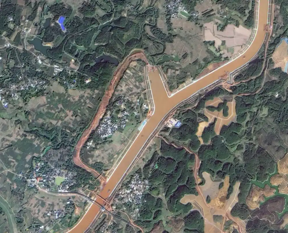
Much of the canal follows existing waterways, including the Shaping River, Jiuzhou River and Qinjiang River. Construction teams widened and deepened these channels and removed bends to meet navigation requirements. A 6.5-kilometer section, however, had no existing riverbed and had to be excavated entirely across dry land and mountainous terrain. Before-and-after satellite images show the creation of this new channel, one of the most difficult civil-engineering sections of the project.

Before-and-After Images of the Pinglu Canal’s Newly Excavated Channel. Most of the Pinglu Canal follows existing waterways, including the Shaping, Jiuzhou and Qinjiang rivers, which were straightened, widened and deepened. A 6.5-kilometer section outlined in red had no existing river channel to follow. Crews had to cut through hills and excavate the channel entirely across dry land, making it one of the most challenging sections of the project.
The imagery also documents extensive changes to the canal’s transport infrastructure. A total of 104 bridges were affected because existing crossings did not provide sufficient vertical or horizontal clearance for 5,000-ton vessels.
At Qinjiang First Bridge, the original structure was demolished and replaced at the same location to increase navigation clearance. Dongba Village Bridge was constructed as an entirely new crossing and became the first permanent cross-canal bridge on the route to open fully to traffic. Together, the bridge works formed what project planners called the canal’s “100-bridge project.”

Before-and-After Images of Qinjiang First Bridge Reconstruction

Before-and-After Images of Dongba Village Bridge Construction
Multi-temporal satellite observation provides a consistent way to examine changes along a linear construction corridor extending across more than 130 kilometers. In addition to recording excavation and bridge replacement, imagery can support comparisons of channel alignment, surrounding land use and the spatial relationship between navigation facilities and existing river systems.
Three Navigation Hubs Overcome 65-Meter Drop
The Madao, Qishi and Qingnian navigation hubs are the canal’s principal control works. Water levels fall by approximately 65 meters between Pingtang River estuary and the canal’s outlet, requiring vessels to pass through a series of ship locks. The three hubs function as staged “water elevators,” raising or lowering vessels as they move between the Xijiang basin and the Beibu Gulf.
Satellite images of the Qingnian hub show the scale of the lock complex and the surrounding transformation before and after construction. The three hubs are critical not only to vessel passage but also to traffic scheduling, water management and the canal’s operational capacity.

Before-and-After Images of Qingnian Hub Construction
The project also carries historical significance. In his 1919 work The International Development of China, Sun Yat-sen proposed using Qinzhou as a maritime outlet to shorten access to the coast for China’s southwestern provinces. More than a century later, the Pinglu Canal realizes that basic geographic concept through a modern, high-capacity navigation corridor.
With the canal entering service, the next test will be operational: coordinating ship movements, lock utilization, port capacity and cargo flows across the Xijiang–Pinglu–Beibu Gulf route. Its economic impact will depend on how quickly shipping services, inland terminals and industrial supply chains adapt to the new connection between southwestern China and ASEAN markets.
Projects such as the Pinglu Canal demonstrate how multi-temporal satellite imagery can provide a consistent, corridor-wide record of channel excavation, bridge reconstruction, waterway realignment and other infrastructure changes. STARPATH GLOBAL helps infrastructure developers, engineering firms and public agencies select imagery with the appropriate resolution and revisit frequency for each monitoring task, delivering sufficient detail without unnecessary data costs. Users can explore our satellite imagery catalog or contact STARPATH GLOBAL to discuss a tailored monitoring workflow. Organizations without in-house remote-sensing experience can also apply for the Pioneer Partner Program, through which our FDE team supports project implementation and personnel training.